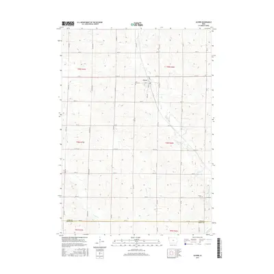
2015 Map of Alvord
USGS Topo · Published 2015About this map
Alvord sits at the heart of this Lyon County landscape, where the local grid of gravel roads and section lines meets the winding course of Mud Creek. This area of northwest Iowa is defined by its agricultural layout, with the town site serving as a central hub for the surrounding township blocks of T99N and T98N. Genealogy researchers will find interest in Saint Marys Cem located just north of the town center, and Hillside Cem situated further south near the border of Lyon and Sioux counties. The eastern edge of the map is defined by the Rock River, which receives several local tributaries including Lizard Cr and Dry Run Cr. The map preserves the specific road designations of the era, from County Highway A42 to the numerous named avenues like Eagle Ave and Dogwood Ave that structure the prairie terrain.
Find a feature on this map
38 named features on this map. Tap any name to fly to it.
Don’t see what you’re looking for? This feature index may not catch every label — zoom into the map to look around manually.
Map Details
Editions of this 2015 Alvord Map
This is the sole edition of this map. No revisions or reprints were ever made.
Other maps of this area

1955 · Sioux Falls
USGS Topo · 1:250,000

1958 · Sioux Falls
USGS Topo · 1:250,000

1964 · Hull
USGS Topo · 1:24,000

1968 · Fairview
USGS Topo · 1:24,000
1968 · Rock Valley
USGS Topo · 1:24,000

1971 · Lester
USGS Topo · 1:24,000
1971 · Inwood
USGS Topo · 1:24,000
1971 · Larchwood
USGS Topo · 1:24,000

1971 · Rock Rapids
USGS Topo · 1:24,000

1971 · Doon
USGS Topo · 1:24,000