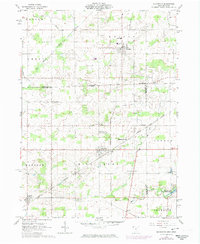
1961 Map of Alvordton
USGS Topo · Published 1974About this map
Alvordton sits at the intersection of the Penn Central and Norfolk and Western railroads, serving as a primary rail hub for the agricultural borderlands of northwest Ohio. This 1961 survey, updated in the early 1970s, documents the rural landscape as it spans the Michigan-Ohio state line. The map illustrates a dense network of country roads connecting small settlements like Kunkle and Primrose, alongside numerous legacy sites for genealogists including Walnut Grove Cem and Olive Branch Ch. To the southeast, the Harrison Lake State Reservation and Harrison Lake provide a recreational contrast to the surrounding township grids. The drainage patterns of the St Joseph River and Mill Creek dictate the placement of early homesteads and cemeteries like the Barrett Cem, preserving a record of settlement patterns before later modernization altered the local character.
Find a feature on this map
36 named features on this map. Tap any name to fly to it.
Don’t see what you’re looking for? This feature index may not catch every label — zoom into the map to look around manually.
Map Details
Editions of this 1961 Alvordton Map
2 editions found
Other maps of this area

1913 · Alvordton
USGS Topo · 1:62,500

1914 · Pioneer
USGS Topo · 1:62,500

1944 · Pioneer
USGS Topo · 1:62,500

1944 · Alvordton
USGS Topo · 1:62,500

1953 · Fort Wayne
USGS Topo · 1:250,000

1956 · Fort Wayne
USGS Topo · 1:250,000

1959 · Frontier
USGS Topo · 1:24,000

1959 · Archbold
USGS Topo · 1:24,000

1960 · Fayette
USGS Topo · 1:24,000
1961 · Pioneer
USGS Topo · 1:24,000