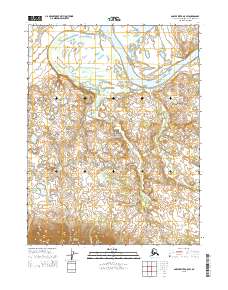
2015 Map of Ambler River A-5 SW
USGS Topo · Published 2015About this map
Kobuk Valley National Park dominates this sub-arctic landscape, where the wide corridor of the Kobuk River snakes through the northern reaches of the quadrangle. The map captures a transition from the broad river valley into the northern foothills of the Waring Mountains to the south. This area is characterized by unique geological formations, most notably the Little Kobuk Sand Dunes, which sit east of the winding Tunutuk Cr. Several tributaries, including Niaktuwik Cr and Nakachelik Cr, drain the tundra and mountain slopes into the primary river system. This survey provides a modern look at the protected wilderness of the Northwest Arctic Borough, detailing the complex network of creeks and elevation changes across the Arctic Circle landscape without any permanent human settlements or roads present within these park boundaries.
Find a feature on this map
12 named features on this map. Tap any name to fly to it.
Don’t see what you’re looking for? This feature index may not catch every label — zoom into the map to look around manually.
Map Details
Editions of this 2015 Ambler River A-5 SW Map
This is the sole edition of this map. No revisions or reprints were ever made.
Other maps of this area

1951 · Shungnak
USGS Topo · 1:250,000

1951 · Ambler River
USGS Topo · 1:250,000

1955 · Shungnak
USGS Topo · 1:250,000

1955 · Ambler River A-6
USGS Topo · 1:63,360

1955 · Shungnak D-6
USGS Topo · 1:63,360

1955 · Shungnak D-5
USGS Topo · 1:63,360

1955 · Ambler River A-5
USGS Topo · 1:63,360

1956 · Ambler River
USGS Topo · 1:250,000

1964 · Shungnak
USGS Topo · 1:250,000

1964 · Ambler River
USGS Topo · 1:250,000