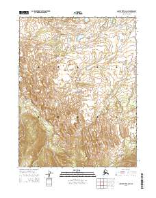
2015 Map of Ambler River A-6 SW
USGS Topo · Published 2015About this map
Kobuk Valley National Park encompasses this portion of the Alaskan interior, centered on one of the Arctic's most unusual geological formations. The Great Kobuk Sand Dunes rise south of the Kobuk Valley National Park boundary, creating a striking landscape of shifting sediment within a region otherwise defined by permafrost and tundra. This environment is drained by a network of seasonal and perennial waterways, including Ahnewetut Cr flowing north through the central sections and Kavet Cr to the west. In the southeastern corner, Niaktuvik Cr winds through the hills, providing a window into the remote hydrology of the Northwest Arctic. The map also delineates several township and range boundaries, such as t20n r1w and t19n r2w, which establish the public land survey system in this wilderness area.
Find a feature on this map
11 named features on this map. Tap any name to fly to it.
Don’t see what you’re looking for? This feature index may not catch every label — zoom into the map to look around manually.
Map Details
Editions of this 2015 Ambler River A-6 SW Map
This is the sole edition of this map. No revisions or reprints were ever made.
Other maps of this area

1951 · Baird Mountains
USGS Topo · 1:250,000

1951 · Selawik
USGS Topo · 1:250,000

1951 · Shungnak
USGS Topo · 1:250,000

1951 · Ambler River
USGS Topo · 1:250,000

1955 · Shungnak
USGS Topo · 1:250,000

1955 · Baird Mountains A-1
USGS Topo · 1:63,360

1955 · Ambler River A-6
USGS Topo · 1:63,360

1955 · Shungnak D-6
USGS Topo · 1:63,360
1955 · Selawik D-1
USGS Topo · 1:63,360

1956 · Ambler River
USGS Topo · 1:250,000