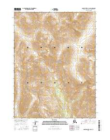
2016 Map of Ambler River B-1 NE
USGS Topo · Published 2016About this map
The Schwatka Mountains dominate this high-latitude terrain within the Gates of the Arctic National Park. This portion of the Brooks Range is defined by a dense network of alpine drainages that flow southward from high ridges. The Ipnetivik River and Kogoluktuk River serve as primary arterial waterways through the central and western sections of the map, while the Igning River carves through the eastern reaches. The landscape reflects the undisturbed character of one of the nation's most northern protected wilderness areas, shown here without roads or permanent settlements. Researchers can observe the complex topographical patterns of the southern slopes, including the headwaters of Kutarlak Cr, which help define the watershed boundaries of the Northwest Arctic Borough.
Find a feature on this map
10 named features on this map. Tap any name to fly to it.
Don’t see what you’re looking for? This feature index may not catch every label — zoom into the map to look around manually.
Map Details
Editions of this 2016 Ambler River B-1 NE Map
This is the sole edition of this map. No revisions or reprints were ever made.
Other maps of this area

1951 · Survey Pass
USGS Topo · 1:250,000

1951 · Ambler River
USGS Topo · 1:250,000

1956 · Survey Pass
USGS Topo · 1:250,000

1956 · Ambler River
USGS Topo · 1:250,000

1964 · Survey Pass
USGS Topo · 1:250,000

1964 · Ambler River
USGS Topo · 1:250,000

1966 · Survey Pass
USGS Topo · 1:250,000
1990 · Ambler River C-1
USGS Topo · 1:63,360
1990 · Ambler River B-1
USGS Topo · 1:63,360
1990 · Survey Pass C-6
USGS Topo · 1:63,360