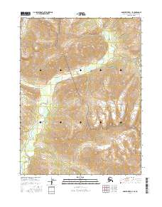
2016 Map of Ambler River B-1 SE
USGS Topo · Published 2016About this map
Kogoluktuk River dominates this remote landscape, its winding course carving through the mountainous terrain of the Brooks Range. This section of the Arctic wilderness is largely defined by its inclusion in the Gates of the Arctic National Park, a vast protected area that remains one of the most untouched regions in the United States. The topography is marked by steep elevation changes and intricate drainage patterns, illustrating the raw geography of the Northwest Arctic Borough. Public Land Survey System boundaries, including t23n r12e and t22n r13e, provide the only geometric structure to an otherwise fluid, natural environment. For those studying the northernmost reaches of Alaska, this map provides a clear look at the intersection of protected federal land and the wild river systems that shape the northern interior.
Find a feature on this map
8 named features on this map. Tap any name to fly to it.
Don’t see what you’re looking for? This feature index may not catch every label — zoom into the map to look around manually.
Map Details
Editions of this 2016 Ambler River B-1 SE Map
This is the sole edition of this map. No revisions or reprints were ever made.
Other maps of this area

1951 · Survey Pass
USGS Topo · 1:250,000

1951 · Ambler River
USGS Topo · 1:250,000

1956 · Survey Pass
USGS Topo · 1:250,000

1956 · Ambler River
USGS Topo · 1:250,000

1964 · Survey Pass
USGS Topo · 1:250,000

1964 · Ambler River
USGS Topo · 1:250,000

1966 · Survey Pass
USGS Topo · 1:250,000
1985 · Ambler River A-1
USGS Topo · 1:63,360
1986 · Survey Pass A-6
USGS Topo · 1:63,360
1990 · Ambler River B-1
USGS Topo · 1:63,360