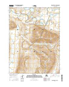
2016 Map of Ambler River D-2 SE
USGS Topo · Published 2016About this map
Noatak National Preserve and Gates of the Arctic National Park meet in this remote northern landscape, where the meandering Noatak River transitions from the broad alluvial plains of the west into the steeper elevations of the Brooks Range to the east. The river system is the central corridor of the region, flanked by significant tributaries including Douglas Cr and Kavachurak Creek. The mapping reveals a stark wilderness transition where the flat-bottomed valley floor, marked by numerous oxbows and marshy lowlands, abruptly gives way to the rising contours of the mountain foothills. This 2016 survey documents the untouched hydrography of the Tunukuchiak Cr drainage as it carves through the eastern portion of the quadrangle, providing a precise record of these shifting arctic waterways within the federally protected wilderness boundaries.
Find a feature on this map
13 named features on this map. Tap any name to fly to it.
Don’t see what you’re looking for? This feature index may not catch every label — zoom into the map to look around manually.
Map Details
Editions of this 2016 Ambler River D-2 SE Map
This is the sole edition of this map. No revisions or reprints were ever made.
Other maps of this area

1951 · Ambler River
USGS Topo · 1:250,000

1956 · Ambler River
USGS Topo · 1:250,000

1964 · Ambler River
USGS Topo · 1:250,000
1990 · Ambler River C-1
USGS Topo · 1:63,360
1990 · Ambler River D-1
USGS Topo · 1:63,360
1990 · Ambler River D-2
USGS Topo · 1:63,360
1990 · Ambler River C-2
USGS Topo · 1:63,360
2016 · Ambler River C-1 NW
USGS Topo · 1:25,000
2016 · Ambler River D-2 SW
USGS Topo · 1:25,000
2016 · Ambler River C-2 NW
USGS Topo · 1:25,000