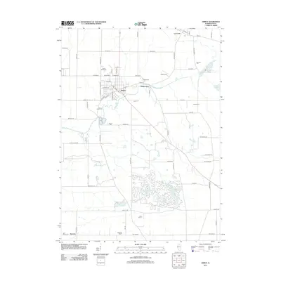
2012 Map of Amboy
USGS Topo · Published 2012About this map
The Green River meanders through this Lee County landscape, anchoring a region of agricultural steadiness and small-town continuity. The city of Amboy serves as the central hub, supported by the smaller communities of Binghamton and Lee Center. This 2012 survey illustrates a landscape deeply connected to its past through numerous burial grounds, including the historic Prairie Repose Cem, Saint Patrick's Cem, and the uniquely named Mormon Cem. To the south, the development around Woodhaven Lake, Black Oak Lake, and Lake Sunset reveals a shift toward recreational land use amidst the traditional farmsteads like Kessel Farms and Setchell Farms. Small-scale aviation also marks the area, with both Taylor Airport and Leffelman Airport situated near the townships. The preservation of these family and community landmarks alongside modern residential clusters provides a clear view of how rural Illinois communities balance heritage with evolving land use.
Find a feature on this map
65 named features on this map. Tap any name to fly to it.
Don’t see what you’re looking for? This feature index may not catch every label — zoom into the map to look around manually.
Map Details
Editions of this 2012 Amboy Map
This is the sole edition of this map. No revisions or reprints were ever made.
Other maps of this area

1918 · Dixon
USGS Topo · 1:62,500

1950 · Dixon
USGS Topo · 1:62,500

1951 · Amboy
USGS Topo · 1:62,500

1952 · Rochelle
USGS Topo · 1:62,500

1952 · Mendota
USGS Topo · 1:62,500

1958 · Aurora
USGS Topo · 1:250,000

1961 · Aurora
USGS Topo · 1:250,000
1975 · Ashton
USGS Topo · 1:24,000
1982 · Ohio
USGS Topo · 1:24,000
1982 · Sublette
USGS Topo · 1:24,000