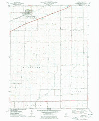
1975 Map of Ashton
USGS Topo · Published 1978About this map
The village of Ashton serves as the primary hub in this corner of Lee County, established along the Chicago and North Western Track. The landscape is dominated by the grid of the Third Principal Meridian, where agricultural land is neatly partitioned by a network of rural routes like Perry Road and Reynolds Road. Infrastructure of the mid-1970s is evident in the presence of the Illinois Tollway cutting across the northern sections, contrasted by localized landmarks such as the Sword Landing Strip and a municipal Sewage Disposal plant.
Find a feature on this map
34 named features on this map. Tap any name to fly to it.
Don’t see what you’re looking for? This feature index may not catch every label — zoom into the map to look around manually.
Map Details
Editions of this 1975 Ashton Map
This is the sole edition of this map. No revisions or reprints were ever made.
Other maps of this area

1918 · Dixon
USGS Topo · 1:62,500

1950 · Dixon
USGS Topo · 1:62,500

1951 · Amboy
USGS Topo · 1:62,500

1952 · Rochelle
USGS Topo · 1:62,500

1952 · Mendota
USGS Topo · 1:62,500

1958 · Aurora
USGS Topo · 1:250,000

1961 · Aurora
USGS Topo · 1:250,000
1975 · Rochelle
USGS Topo · 1:24,000
1975 · Steward
USGS Topo · 1:24,000
1975 · Chana
USGS Topo · 1:24,000