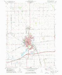
1975 Map of Rochelle
USGS Topo · Published 1978About this map
Rochelle serves as a significant rail and transportation crossroads where the Chicago and North Western and Chicago Milwaukee St Paul and Pacific lines intersect. The 1970s landscape shows a community built on both industry and civic infrastructure, featuring a dense network of local schools like Tilton Sch and Lincoln Sch, and several public spaces including Sweeney Park and Connolly Park. The Kyte River and Spring Lake provide the primary natural drainage through this corner of Ogle County, while the Illinois Tollway cuts across the southern portion of the quadrangle.
Find a feature on this map
51 named features on this map. Tap any name to fly to it.
Don’t see what you’re looking for? This feature index may not catch every label — zoom into the map to look around manually.
Map Details
Editions of this 1975 Rochelle Map
This is the sole edition of this map. No revisions or reprints were ever made.
Other maps of this area

1917 · Kings
USGS Topo · 1:62,500

1918 · Kings
USGS Topo · 1:62,500

1918 · Kirkland
USGS Topo · 1:62,500

1934 · De Kalb
USGS Topo · 1:62,500

1937 · De Kalb
USGS Topo · 1:62,500

1952 · Rochelle
USGS Topo · 1:62,500

1954 · Rockford
USGS Topo · 1:250,000

1955 · Rockford
USGS Topo · 1:250,000

1958 · Aurora
USGS Topo · 1:250,000

1958 · Rockford
USGS Topo · 1:250,000