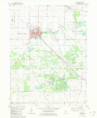
1982 Map of Amboy
USGS Topo · Published 1983About this map
The Illinois Central Gulf and Burlington Northern railroads intersect at the heart of Amboy, marking its historical identity as a transportation junction. This early 1980s landscape shows the transition from the dense industrial activity of the Green River Industrial Park to the surrounding agricultural prairie. To the east, Binghamton and Lee Center maintain their distinct characters, connected by a network of rural routes like Shaw Road. Local history is deeply etched into the terrain through numerous burial sites, including Prairie Repose Cem and the remote Sandy Hill Cem. Southward, the landscape shifts toward recreation and water resources, evidenced by the clustered waters of Woodhaven Lake, Bass Lake, and Lake Sunset. The presence of several quarries and sandpits suggests the ongoing importance of local mineral extraction alongside the traditional farming economy in Lee County.
Find a feature on this map
56 named features on this map. Tap any name to fly to it.
Don’t see what you’re looking for? This feature index may not catch every label — zoom into the map to look around manually.
Map Details
Editions of this 1982 Amboy Map
This is the sole edition of this map. No revisions or reprints were ever made.
Other maps of this area

1918 · Dixon
USGS Topo · 1:62,500

1950 · Dixon
USGS Topo · 1:62,500

1951 · Amboy
USGS Topo · 1:62,500

1952 · Rochelle
USGS Topo · 1:62,500

1952 · Mendota
USGS Topo · 1:62,500

1958 · Aurora
USGS Topo · 1:250,000

1961 · Aurora
USGS Topo · 1:250,000
1975 · Ashton
USGS Topo · 1:24,000
1982 · Ohio
USGS Topo · 1:24,000
1982 · Sublette
USGS Topo · 1:24,000