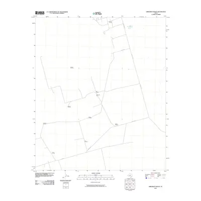
2010 Map of Amburgey Ranch
USGS Topo · Published 2010About this map
Amburgey Ranch sits at the center of this Ector County landscape, defined by a sparse network of roads and the industrial presence of the Wheeler Oil Field. The terrain is marked by a distinctive infrastructure of named water-pumping sites, including Wheeler Windmills and Jeff Windmill, which speak to the area's agricultural and ranching reliance on groundwater in West Texas. These landmarks often serve as primary navigational points in an otherwise open country. The road system is dominated by straight-line segments such as S Wheeler Rd and Blockline Rd, reflecting the grid-based surveying typical of the Permian Basin. This survey preserves a specific moment in the rural development of the region, showing the intersection of traditional ranching life with the energy extraction operations that have shaped Ector County's modern history.
Find a feature on this map
14 named features on this map. Tap any name to fly to it.
Don’t see what you’re looking for? This feature index may not catch every label — zoom into the map to look around manually.
Map Details
Editions of this 2010 Amburgey Ranch Map
This is the sole edition of this map. No revisions or reprints were ever made.
Other maps of this area

1954 · Pecos
USGS Topo · 1:250,000

1957 · Pecos
USGS Topo · 1:250,000

1964 · Turnbaugh Corner
USGS Topo · 1:24,000

1964 · Metz
USGS Topo · 1:24,000

1964 · Red Lakes
USGS Topo · 1:24,000

1968 · Cowden Place
USGS Topo · 1:24,000

1968 · China Ranch
USGS Topo · 1:24,000

1971 · Notrees
USGS Topo · 1:24,000

1971 · Notrees NW
USGS Topo · 1:24,000
1971 · Amburgey Ranch
USGS Topo · 1:24,000