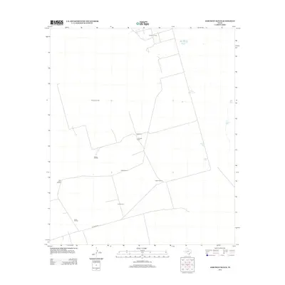
2012 Map of Amburgey Ranch
USGS Topo · Published 2012About this map
Amburgey Ranch sits at the center of this 2012 survey, illustrating the pastoral and industrial landscape of the West Texas plains. The area is defined by its extensive water management and energy infrastructure, notably the Wheeler Oil Field in the north. A network of family-named water sources and power-generating landmarks, such as Jeff Windmill, Mitchell Windmill, and Little China Windmill, are scattered across the terrain to support ranching operations. The infrastructure reveals the necessity of managed water in this arid region, highlighted by several reservoirs including White Horse Tank, Bumper Tank, and Ector Tank. To the south, Blockline Rd provides one of the few named navigational markers through this sparsely populated territory, connecting the various windmill sites like Charlie Windmill and Sun Windmill to the surrounding Ector County land.
Find a feature on this map
16 named features on this map. Tap any name to fly to it.
Don’t see what you’re looking for? This feature index may not catch every label — zoom into the map to look around manually.
Map Details
Editions of this 2012 Amburgey Ranch Map
This is the sole edition of this map. No revisions or reprints were ever made.
Other maps of this area

1954 · Pecos
USGS Topo · 1:250,000

1957 · Pecos
USGS Topo · 1:250,000

1964 · Turnbaugh Corner
USGS Topo · 1:24,000

1964 · Metz
USGS Topo · 1:24,000

1964 · Red Lakes
USGS Topo · 1:24,000

1968 · Cowden Place
USGS Topo · 1:24,000

1968 · China Ranch
USGS Topo · 1:24,000

1971 · Notrees
USGS Topo · 1:24,000

1971 · Notrees NW
USGS Topo · 1:24,000
1971 · Amburgey Ranch
USGS Topo · 1:24,000