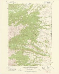
1972 Map of Amelong Creek
USGS Topo · Published 1976About this map
Gallatin National Forest dominates this topographic landscape, defined by the deep drainage systems of Big Timber Creek and its many tributaries. The area is characterized by high-elevation landmarks such as Black Butte and the alpine basin of Wolf Park, where seasonal springs feed the headwaters of Dry Creek and Sweet Grass Creek. This map captures a moment of active forest management and recreational transition, featuring the Big Timber Guard Station and the Half Moon Campground near the base of the Big Timber Canyon. The network of Pack Trails and Jeep Trails shown throughout the terrain suggests a region focused on resource protection and backcountry access. Local agricultural water management is evident at the lower elevations, where the Stocker Ditch diverts water from the main creek systems.
Find a feature on this map
23 named features on this map. Tap any name to fly to it.
Don’t see what you’re looking for? This feature index may not catch every label — zoom into the map to look around manually.
Map Details
Editions of this 1972 Amelong Creek Map
2 editions found
Other maps of this area

1886 · Little Belt Mts.
USGS Topo · 1:250,000

1891 · Livingston
USGS Topo · 1:250,000

1893 · Livingston
USGS Topo · 1:250,000

1894 · Little Belt Mts.
USGS Topo · 1:250,000

1897 · Little Belt Mts.
USGS Topo · 1:250,000

1898 · Little Belt Mts.
USGS Topo · 1:250,000

1902 · Little Belt Mts.
USGS Topo · 1:250,000

1947 · Bozeman
USGS Topo · 1:250,000

1948 · Bozeman
USGS Topo · 1:250,000

1948 · White Sulphur Springs
USGS Topo · 1:250,000