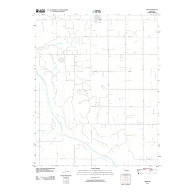
2009 Map of Ames
USGS Topo · Published 2009About this map
Ames anchors the northern edge of this agricultural landscape in Major County, organized around a rigid section-line road grid. The town sits just south of Ames Rd and E0530 Rd, serving as a hub for the surrounding rural territory. The natural geography is defined by the winding course of the Cimarron River, which cuts through the southwestern portion of the sheet. Numerous tributaries and drainages, most notably Hoyle Creek, meander across the plains to meet the river, often accompanied by small water bodies like Silver Lake. This 2009 survey by the U.S. Geological Survey illustrates the intersection of human engineering and the prairie river system, where numbered county roads like N2700 Rd and E0550 Rd cross the uneven terrain of the creek bottoms.
Find a feature on this map
20 named features on this map. Tap any name to fly to it.
Don’t see what you’re looking for? This feature index may not catch every label — zoom into the map to look around manually.
Map Details
Editions of this 2009 Ames Map
This is the sole edition of this map. No revisions or reprints were ever made.
Other maps of this area

1893 · Ames
USGS Topo · 1:62,500

1955 · Woodward
USGS Topo · 1:250,000

1956 · Ames
USGS Topo · 1:62,500

1956 · Ringwood
USGS Topo · 1:62,500

1958 · Woodward
USGS Topo · 1:250,000

1969 · Fairview SE
USGS Topo · 1:24,000

1972 · Okeene
USGS Topo · 1:24,000
1972 · Isabella
USGS Topo · 1:24,000
1982 · Barr
USGS Topo · 1:24,000
1982 · Ringwood SW
USGS Topo · 1:24,000