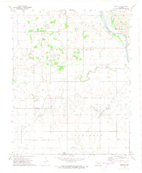
1972 Map of Isabella
USGS Topo · Published 1974About this map
The settlement of Isabella and the northern edge of Okeene anchor this 1970s survey of the Oklahoma plains along the Major Co Blaine Co border. The landscape is defined by the sweeping course of the Cimarron River in the northeast and a dense network of energy infrastructure, with numerous Gas Wells and Oil Wells peppered across the townships of Homestead and Deep Creek. The map documents a critical intersection of western commerce, featuring the Chicago Rock Island and Pacific and St Louis San Francisco railroad lines traversing the prairie. For genealogists, the map is a vital record of local heritage, preserving the locations of family and community burial grounds including Isabella Cem, Bierig Cem, Calvary Cem, and Collins Cem. These landmarks, alongside several quarries, provide a clear picture of the industrial and social footprint of these rural communities just after the mid-century peak of the regional petroleum boom.
Find a feature on this map
21 named features on this map. Tap any name to fly to it.
Don’t see what you’re looking for? This feature index may not catch every label — zoom into the map to look around manually.
Map Details
Editions of this 1972 Isabella Map
This is the sole edition of this map. No revisions or reprints were ever made.
Other maps of this area

1893 · Ames
USGS Topo · 1:62,500

1955 · Woodward
USGS Topo · 1:250,000

1956 · Ames
USGS Topo · 1:62,500

1956 · Ringwood
USGS Topo · 1:62,500

1958 · Woodward
USGS Topo · 1:250,000

1969 · Fairview SE
USGS Topo · 1:24,000

1969 · Fairview
USGS Topo · 1:24,000

1972 · Southard
USGS Topo · 1:24,000

1972 · Okeene
USGS Topo · 1:24,000

1972 · Homestead
USGS Topo · 1:24,000