
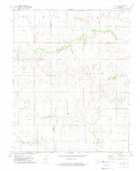
1972 Map of Okeene
USGS Topo · Published 1974About this map
Okeene serves as the focal point of this 1970s landscape, situated at the junction of significant rail corridors including the St Louis - San Francisco, the Chicago and North Western, and the Chicago Rock Island and Pacific. This concentration of infrastructure highlights the town's role as a regional hub for the surrounding agricultural townships of Homestead, Flynn, and Seay. The terrain is defined by the winding paths of Spring Creek and Salt Creek, which drain toward the Cimarron river.
Find a feature on this map
19 named features on this map. Tap any name to fly to it.
Don’t see what you’re looking for? This feature index may not catch every label — zoom into the map to look around manually.
Map Details
Editions of this 1972 Okeene Map
This is the sole edition of this map. No revisions or reprints were ever made.
Other maps of this area

1893 · Loyal
USGS Topo · 1:62,500

1893 · Ames
USGS Topo · 1:62,500

1955 · Clinton
USGS Topo · 1:250,000

1955 · Woodward
USGS Topo · 1:250,000

1956 · Ames
USGS Topo · 1:62,500

1957 · Clinton
USGS Topo · 1:250,000

1958 · Woodward
USGS Topo · 1:250,000
1972 · Loyal NW
USGS Topo · 1:24,000

1972 · Southard
USGS Topo · 1:24,000

1972 · Homestead
USGS Topo · 1:24,000