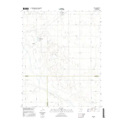
2016 Map of Ames
USGS Topo · Published 2016About this map
The town of Ames anchors the northern edge of this Oklahoma landscape, situated at the intersection of Main St and Alva St. The surrounding terrain in Major County is defined by the broad path of the Cimarron River, which cuts across the southwestern corner of the quadrangle. North of the river, the small residential developments of Crystal Lakes and Lindley sit near the waters of Silver Lake and the winding course of Hoyle Creek. The area is organized by a precise grid of rural roads, including Ames Rd and various numbered routes like N2700 Rd, which connect the scattered homesteads and farms of this agricultural region. This map also marks the convergence of three county lines where Major, Blaine, and Kingfisher counties meet along the river basin.
Find a feature on this map
29 named features on this map. Tap any name to fly to it.
Don’t see what you’re looking for? This feature index may not catch every label — zoom into the map to look around manually.
Map Details
Editions of this 2016 Ames Map
This is the sole edition of this map. No revisions or reprints were ever made.
Other maps of this area

1893 · Ames
USGS Topo · 1:62,500

1955 · Woodward
USGS Topo · 1:250,000

1956 · Ames
USGS Topo · 1:62,500

1956 · Ringwood
USGS Topo · 1:62,500

1958 · Woodward
USGS Topo · 1:250,000

1969 · Fairview SE
USGS Topo · 1:24,000

1972 · Okeene
USGS Topo · 1:24,000
1972 · Isabella
USGS Topo · 1:24,000
1982 · Barr
USGS Topo · 1:24,000
1982 · Ringwood SW
USGS Topo · 1:24,000