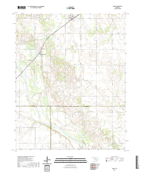
2022 Map of Ames
USGS Topo · Published 2022About this map
Ames serves as the primary hub in this corner of Major County, where the street grid of Alva St and Cleo St meets the open agricultural landscape of northwestern Oklahoma. The geography is defined by the winding course of the Cimarron River, which cuts across the southern portion of the map, and the seasonal drainage of Hoyle Cr to the north. These waterways have historically shaped the settlement patterns and road networks that divide the plains into a precise grid of section lines.
Find a feature on this map
36 named features on this map. Tap any name to fly to it.
Don’t see what you’re looking for? This feature index may not catch every label — zoom into the map to look around manually.
Map Details
Editions of this 2022 Ames Map
This is the sole edition of this map. No revisions or reprints were ever made.
Other maps of this area

1893 · Ames
USGS Topo · 1:62,500

1955 · Woodward
USGS Topo · 1:250,000

1956 · Ames
USGS Topo · 1:62,500

1956 · Ringwood
USGS Topo · 1:62,500

1958 · Woodward
USGS Topo · 1:250,000

1969 · Fairview SE
USGS Topo · 1:24,000

1972 · Okeene
USGS Topo · 1:24,000
1972 · Isabella
USGS Topo · 1:24,000
1982 · Barr
USGS Topo · 1:24,000
1982 · Ringwood SW
USGS Topo · 1:24,000