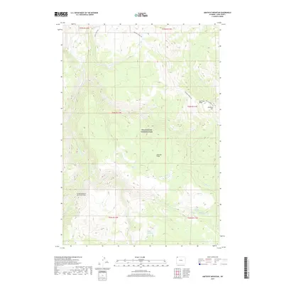
2017 Map of Amethyst Mountain
USGS Topo · Published 2017About this map
Specimen Ridge and the towering heights of Amethyst Mtn dominate this high-altitude landscape within Yellowstone National Park. The topography reveals a complex network of drainage basins feeding the Yellowstone River, which carves through the southwestern corner of the sheet at the Grand Canyon of the Yellowstone. This area of the Absaroka Range is characterized by its geothermal and hydrological diversity, featuring Coffee Pot Hot Springs and the secluded Rainbow Springs near Wrong Cr. Backcountry access is documented through established routes like the Specimen Ridge Trail and Agate Creek Trail, which navigate the steep elevations between major watercourses such as Agate Cr and Deep Cr. The map provides a detailed view of the natural forest boundaries and creek systems that define this protected wilderness.
Find a feature on this map
24 named features on this map. Tap any name to fly to it.
Don’t see what you’re looking for? This feature index may not catch every label — zoom into the map to look around manually.
Map Details
Editions of this 2017 Amethyst Mountain Map
This is the sole edition of this map. No revisions or reprints were ever made.
Other maps of this area

1886 · Canyon
USGS Topo · 1:125,000

1895 · Canyon
USGS Topo · 1:125,000

1896 · Canyon
USGS Topo · 1:125,000

1901 · Canyon
USGS Topo · 1:125,000

1907 · Canyon
USGS Topo · 1:125,000

1911 · Canyon
USGS Topo · 1:125,000

1955 · Ashton
USGS Topo · 1:250,000

1958 · Ashton
USGS Topo · 1:250,000
1959 · Pelican Cone
USGS Topo · 1:62,500
1959 · Canyon Village
USGS Topo · 1:62,500