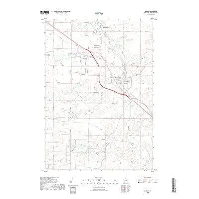
2018 Map of Amherst
USGS Topo · Published 2018About this map
Amherst and Amherst Junction form the primary population centers on this central Wisconsin landscape, situated along the rolling terrain of eastern Portage County. The survey illustrates a region defined by its glacial hydrology, featuring numerous kettle lakes and waterways such as the Tomorrow River and Waupaca River. A dense network of rural roads, including Old Hwy 18 and Co Trunk Hwy SS, connects these settlements to the surrounding agricultural land. For genealogists, the map provides precise locations for several historic burial sites, including the Saint Mary of Mount Carmel Cem and the Lower Amherst Cem. The concentration of cemeteries and small lakefront communities like Nelsonville reflects a well-established rural social structure centered on localized water resources and transportation corridors.
Find a feature on this map
88 named features on this map. Tap any name to fly to it.
Don’t see what you’re looking for? This feature index may not catch every label — zoom into the map to look around manually.
Map Details
Editions of this 2018 Amherst Map
This is the sole edition of this map. No revisions or reprints were ever made.
Other maps of this area

1955 · Tigerton
USGS Topo · 1:48,000

1955 · Rosholt
USGS Topo · 1:48,000

1955 · Green Bay
USGS Topo · 1:250,000

1957 · Amherst
USGS Topo · 1:48,000

1957 · Waupaca
USGS Topo · 1:48,000
1969 · King
USGS Topo · 1:24,000
1969 · Blaine
USGS Topo · 1:24,000

1969 · New Hope
USGS Topo · 1:24,000

1969 · Arnott
USGS Topo · 1:24,000
1969 · Almond
USGS Topo · 1:24,000