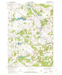
1969 Map of Amherst
USGS Topo · Published 1972About this map
Nelsonville and Amherst anchor this central Wisconsin landscape during a period of steady rural development in Portage County. The Green Bay and Western railroad corridor cuts northwest across the terrain, serving as a primary transit artery between Amherst Junction and the lake-dotted townships of Stockton and Amherst. The water system is particularly prominent, centered on the Tomorrow River as it flows from the Nelsonville Pond through Amherst, past a local Fish Hatchery and several smaller glacial lakes like Lake Emily and Turtle Lake.
Find a feature on this map
45 named features on this map. Tap any name to fly to it.
Don’t see what you’re looking for? This feature index may not catch every label — zoom into the map to look around manually.
Map Details
Editions of this 1969 Amherst Map
This is the sole edition of this map. No revisions or reprints were ever made.
Other maps of this area

1955 · Tigerton
USGS Topo · 1:48,000

1955 · Rosholt
USGS Topo · 1:48,000

1955 · Green Bay
USGS Topo · 1:250,000

1957 · Amherst
USGS Topo · 1:48,000

1957 · Waupaca
USGS Topo · 1:48,000
1969 · King
USGS Topo · 1:24,000
1969 · Blaine
USGS Topo · 1:24,000

1969 · New Hope
USGS Topo · 1:24,000

1969 · Arnott
USGS Topo · 1:24,000
1969 · Almond
USGS Topo · 1:24,000