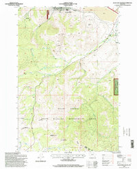
1996 Map of Anaconda South
USGS Topo · Published 1998About this map
Industrial history and mountain geography meet at the southern edge of Anaconda, where the massive Anaconda Smelter Stack and extensive Tailings fields dominate the northern horizon. The landscape transitions quickly from the civic center, featuring the Courthouse, Lincoln School, and a local Cemetery, into the steep, timbered slopes of the Deerlodge National Forest. To the south, the Continental Divide snakes through the high country, crossing over Sugarloaf Mountain and defining the southern boundary of the Mount Haggin State Wildlife Management Area. Numerous drainage systems including Mill Creek, Silver Creek, and Willow Creek carve through the terrain, which is marked by legacy mining activity such as several Prospects and a Quarry. This map captures the region's character as a nexus of large-scale metallurgy and protected Montana wilderness.
Find a feature on this map
31 named features on this map. Tap any name to fly to it.
Don’t see what you’re looking for? This feature index may not catch every label — zoom into the map to look around manually.
Map Details
Editions of this 1996 Anaconda South Map
This is the sole edition of this map. No revisions or reprints were ever made.
Other maps of this area

1889 · Helena
USGS Topo · 1:250,000

1893 · Helena
USGS Topo · 1:250,000

1893 · Dillon
USGS Topo · 1:250,000

1899 · Helena
USGS Topo · 1:250,000

1903 · Helena
USGS Topo · 1:250,000

1908 · Philipsburg
USGS Topo · 1:125,000

1947 · Butte
USGS Topo · 1:250,000

1955 · Dillon
USGS Topo · 1:250,000

1957 · Dillon
USGS Topo · 1:250,000

1958 · Butte
USGS Topo · 1:250,000