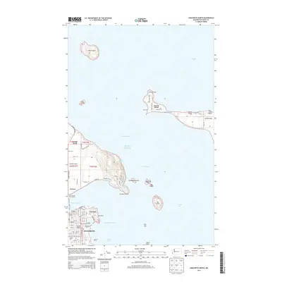
2014 Map of Anacortes North
USGS Topo · Published 2014About this map
Anacortes and its neighboring island communities are detailed here, centered on the busy waterways of Puget Sound and Padilla Bay. On Guemes Island, the settlement of Guemes connects to the mainland via the Guemes Island Ferry Landing, while the interior is marked by Eden Cem and a network of local roads like Edens Rd. To the north, Samish Island stretches into Samish Bay, featuring waterfront areas such as Samish Beach and Blue Heron Beach. The maritime character of the region is evident in the concentration of facilities like the Port of Anacortes, Anchor Cove Marina, and Cap Sante Marine. Numerous smaller islands dot the surrounding passages, including Vendovi Island, Saddlebag Island, and Hat Island, serving as landmarks for those navigating the Levant Passage and Guemes Channel.
Find a feature on this map
79 named features on this map. Tap any name to fly to it.
Don’t see what you’re looking for? This feature index may not catch every label — zoom into the map to look around manually.
Map Details
Editions of this 2014 Anacortes North Map
This is the sole edition of this map. No revisions or reprints were ever made.
Other maps of this area

1911 · Mount Vernon
USGS Topo · 1:125,000

1918 · Samish Lake
USGS Topo · 1:62,500

1940 · Mt Vernon
USGS Topo · 1:62,500

1943 · Mt Vernon
USGS Topo · 1:62,500

1943 · Deception Pass
USGS Topo · 1:62,500

1943 · Anacortes
USGS Topo · 1:62,500

1951 · Deception Pass
USGS Topo · 1:62,500

1951 · Anacortes
USGS Topo · 1:62,500

1954 · Bow
USGS Topo · 1:24,000
1954 · Bellingham South
USGS Topo · 1:24,000