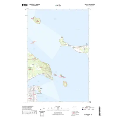
2020 Map of Anacortes North
USGS Topo · Published 2020About this map
Anacortes anchors the southern edge of this maritime survey, where the Pacific NW National Scenic Trail winds through the city’s northeastern peninsula. The landscape is defined by the complex waterways of Bellingham Bay and Padilla Bay, connecting the mainland to a series of rugged islands. To the north, Guemes Island is accessible via the Guemes Island Ferry, supporting small settlements like Guemes and waterfront residential tracts along Holiday Blvd. The map captures the distinct character of Samish Island to the east, home to Samish Beach and Blue Heron Beach. This modern topographic study illustrates the persistence of coastal communities and the strategic importance of points like Cap Sante and March Point in the Skagit County sound. Smaller landmasses such as Saddlebag Island and Vendovi Island stand as prominent landmarks within the open waters of Samish Bay and Levant Passage.
Find a feature on this map
52 named features on this map. Tap any name to fly to it.
Don’t see what you’re looking for? This feature index may not catch every label — zoom into the map to look around manually.
Map Details
Editions of this 2020 Anacortes North Map
This is the sole edition of this map. No revisions or reprints were ever made.
Other maps of this area

1911 · Mount Vernon
USGS Topo · 1:125,000

1918 · Samish Lake
USGS Topo · 1:62,500

1940 · Mt Vernon
USGS Topo · 1:62,500

1943 · Mt Vernon
USGS Topo · 1:62,500

1943 · Deception Pass
USGS Topo · 1:62,500

1943 · Anacortes
USGS Topo · 1:62,500

1951 · Deception Pass
USGS Topo · 1:62,500

1951 · Anacortes
USGS Topo · 1:62,500

1954 · Bow
USGS Topo · 1:24,000
1954 · Bellingham South
USGS Topo · 1:24,000