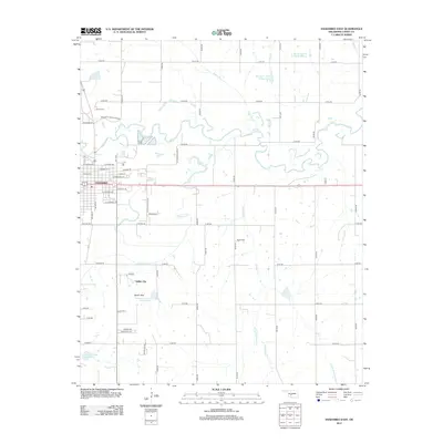
2012 Map of Anadarko East
USGS Topo · Published 2012About this map
The Washita River meanders sharply through the heart of Caddo County, defining the northern geography of Anadarko. In this 2012 depiction, the eastern portion of the city is detailed alongside the neighboring South Hills and the cultural landmark of Indian City. The landscape is a network of rural section roads such as E1320 Rd and N2670 Rd that navigate the drainages of Sugar Cr, Tonkawa Cr, and Delaware Cr. Notable local landmarks include the Beauro of Indian Affairs and two local burial grounds, Kiowa Cem and Roach Cem. This modern topographic study illustrates a region where managed water resources, including the Spring Cr Site 2 Reservoir and Tonkawa Cr Site 5 Reservoir, support a landscape defined by its river-valley history and Indigenous heritage.
Find a feature on this map
59 named features on this map. Tap any name to fly to it.
Don’t see what you’re looking for? This feature index may not catch every label — zoom into the map to look around manually.
Map Details
Editions of this 2012 Anadarko East Map
This is the sole edition of this map. No revisions or reprints were ever made.
Other maps of this area

1945 · Anadarko
USGS Topo · 1:62,500

1949 · Cement
USGS Topo · 1:62,500

1951 · Fort Cobb
USGS Topo · 1:62,500

1955 · Lawton
USGS Topo · 1:250,000

1955 · Clinton
USGS Topo · 1:250,000

1956 · Laverty
USGS Topo · 1:24,000
1956 · Cyril
USGS Topo · 1:24,000

1956 · Apache
USGS Topo · 1:24,000

1956 · Apache
USGS Topo · 1:62,500
1956 · Cement
USGS Topo · 1:62,500