
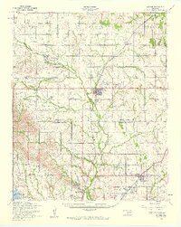
1956 Map of Apache
USGS Topo · Published 1960About this map
Apache serves as the central hub of this mid-century survey, situated at the crossroads of the Chicago Rock Island and Pacific railroad and regional highways. The landscape transitions from the agricultural plateaus of Hale and Highland in the north to the edge of the Fort Sill Military Reservation in the south. This military presence is marked by features like the Elgin Gate and the Elgin Landing Field, reflecting the era's tactical landscape. The map provides significant genealogical value through its documentation of rural sites, including the Comanche Indian Cemetery and the Mahsetka Indian Church. Along the southern boundary, the rugged terrain around Richards Spur overlooks the northern tip of Lake Lawtonka, where an abandoned Fish Hatchery is noted. Smaller communities like Broxton and Stecker punctuate the grid, connected by a network of drainage systems including Cache Creek and Mission Creek.
Find a feature on this map
46 named features on this map. Tap any name to fly to it.
Don’t see what you’re looking for? This feature index may not catch every label — zoom into the map to look around manually.
Map Details
Editions of this 1956 Apache Map
2 editions found
Other maps of this area

1937 · Cache
USGS Topo · 1:48,000

1942 · Cache
USGS Topo · 1:62,500

1945 · Anadarko
USGS Topo · 1:62,500

1946 · Lawton
USGS Topo · 1:62,500

1949 · Mount Scott
USGS Topo · 1:24,000

1949 · Arbuckle Hill
USGS Topo · 1:24,000

1949 · Cement
USGS Topo · 1:62,500

1949 · Elgin
USGS Topo · 1:24,000

1949 · Fort Sill
USGS Topo · 1:24,000

1949 · Nellie
USGS Topo · 1:62,500