
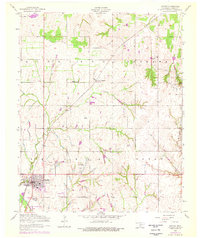
1956 Map of Apache
USGS Topo · Published 1959About this map
The town of Apache serves as the focal point for this mid-century Caddo County survey, revealing a landscape defined by ranching, rail transport, and early oil exploration. The Chicago Rock Island and Pacific railroad cuts diagonally across the terrain, passing through the settlement of Stecker and providing a vital link for the agricultural economy. Local social and religious history is anchored by the J Methvin Mission and Fairview Cemetery, while the Rodeo Grounds west of the main townsite highlight the region's cultural traditions. The drainage pattern is complex, with East Cache Creek and Box Elder Creek carving through the hills, punctuated by industrial markings like slush tanks and pumping stations that indicate the presence of the energy industry. Small rural clusters like Abilene and the Weidenmaier Lakes area show the distributed nature of settlement during this era.
Find a feature on this map
19 named features on this map. Tap any name to fly to it.
Don’t see what you’re looking for? This feature index may not catch every label — zoom into the map to look around manually.
Map Details
Editions of this 1956 Apache Map
2 editions found
Other maps of this area

1945 · Anadarko
USGS Topo · 1:62,500

1949 · Cement
USGS Topo · 1:62,500

1949 · Elgin
USGS Topo · 1:24,000

1951 · Fort Cobb
USGS Topo · 1:62,500

1955 · Lawton
USGS Topo · 1:250,000

1955 · Clinton
USGS Topo · 1:250,000

1956 · Fletcher
USGS Topo · 1:24,000

1956 · Boone
USGS Topo · 1:24,000

1956 · Elgin
USGS Topo · 1:24,000

1956 · Richards Spur
USGS Topo · 1:24,000