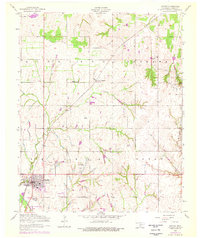
1956 Map of Apache
USGS Topo · Published 1976About this map
Apache serves as the primary hub in this mid-century survey of Caddo County, situated at the intersection of regional infrastructure and agricultural lands. The town plan is captured in detail, showing a City Park, Ball Park, and Rodeo Grounds alongside the vital Chicago Rock Island and Pacific railroad line. Beyond the town limits, the landscape transitions into the hills of Highland Tonkawa and Billie Doyle, where small-scale water management and local transportation are evident through the Manar Landing Strip and the series of small impoundments known as Weidenmaier Lakes.
Find a feature on this map
22 named features on this map. Tap any name to fly to it.
Don’t see what you’re looking for? This feature index may not catch every label — zoom into the map to look around manually.
Map Details
Editions of this 1956 Apache Map
2 editions found

Other maps of this area

1945 · Anadarko
USGS Topo · 1:62,500

1949 · Cement
USGS Topo · 1:62,500

1949 · Elgin
USGS Topo · 1:24,000

1951 · Fort Cobb
USGS Topo · 1:62,500

1955 · Lawton
USGS Topo · 1:250,000

1955 · Clinton
USGS Topo · 1:250,000

1956 · Fletcher
USGS Topo · 1:24,000

1956 · Boone
USGS Topo · 1:24,000

1956 · Elgin
USGS Topo · 1:24,000

1956 · Richards Spur
USGS Topo · 1:24,000