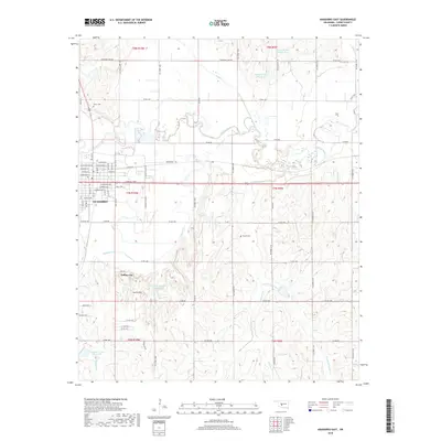
2018 Map of Anadarko East
USGS Topo · Published 2018About this map
The Washita River meanders across the northern portion of this landscape, carving a wide valley as it flows eastward past the city of Anadarko. In the early 21st century, the area shows a distinct transition from the grid-iron streets of the town center to the dispersed rural holdings and recreational developments of Caddo County. South of the river, the terrain rises into the South Hills, where the vanished settlement patterns are replaced by points of interest such as Indian City and several water management projects, including Tonkawa Cr Site 5 Reservoir and Tonkawa Cr Site 1 Reservoir. Local heritage is preserved in sites like the Kiowa Cem and Roach Cem, which remain as fixed points amidst a network of section-line roads. The drainage systems of Tonkawa Cr and Delaware Cr define the southern and eastern quadrants, illustrating the watershed's importance to the region's agricultural layout.
Find a feature on this map
46 named features on this map. Tap any name to fly to it.
Don’t see what you’re looking for? This feature index may not catch every label — zoom into the map to look around manually.
Map Details
Editions of this 2018 Anadarko East Map
This is the sole edition of this map. No revisions or reprints were ever made.
Other maps of this area

1945 · Anadarko
USGS Topo · 1:62,500

1949 · Cement
USGS Topo · 1:62,500

1951 · Fort Cobb
USGS Topo · 1:62,500

1955 · Lawton
USGS Topo · 1:250,000

1955 · Clinton
USGS Topo · 1:250,000

1956 · Laverty
USGS Topo · 1:24,000
1956 · Cyril
USGS Topo · 1:24,000

1956 · Apache
USGS Topo · 1:24,000

1956 · Apache
USGS Topo · 1:62,500
1956 · Cement
USGS Topo · 1:62,500