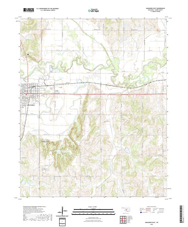
2022 Map of Anadarko East
USGS Topo · Published 2022About this map
Anadarko serves as the focal point of this western Oklahoma landscape, where the Caddo County Courthouse and a dense residential grid of streets like W Washington Ave and E Central Blvd define the town's footprint. The area's geography is deeply tied to the winding Washita River and the convergence of multiple tributaries, including Tonkawa Cr, Sugar Cr, and Delaware Cr. To the south of the river, the South Hills rise near Indian City, while several flood control reservoirs, such as Tonkawa Cr Site 1 Reservoir and Spring Cr Site 2 Reservoir, characterize the regional water management strategy. Genealogists may find value in the documentation of the Riverside Cem on the northern edge of town and the more isolated Roach Cem located in the rural section of t7n r9w.
Find a feature on this map
84 named features on this map. Tap any name to fly to it.
Don’t see what you’re looking for? This feature index may not catch every label — zoom into the map to look around manually.
Map Details
Editions of this 2022 Anadarko East Map
This is the sole edition of this map. No revisions or reprints were ever made.
Other maps of this area

1945 · Anadarko
USGS Topo · 1:62,500

1949 · Cement
USGS Topo · 1:62,500

1951 · Fort Cobb
USGS Topo · 1:62,500

1955 · Lawton
USGS Topo · 1:250,000

1955 · Clinton
USGS Topo · 1:250,000

1956 · Laverty
USGS Topo · 1:24,000
1956 · Cyril
USGS Topo · 1:24,000

1956 · Apache
USGS Topo · 1:24,000

1956 · Apache
USGS Topo · 1:62,500
1956 · Cement
USGS Topo · 1:62,500