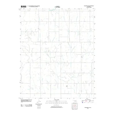
2009 Map of Anadarko NE
USGS Topo · Published 2009About this map
Jack Hollow Creek and Ionie Creek Site 101 Reservoir anchor this section of Grady County, where the landscape is defined by a grid of rural section roads and winding watercourses. The drainage patterns of West Ionine Creek and East Ionine Creek illustrate the natural topography that shaped early settlement and agricultural boundaries in this part of Oklahoma. In the southern reaches of the map, the Northeast Verden Oil Field indicates the region's long-standing connection to the petroleum industry, while the presence of Liberty Cemetery near Cemetery Rd offers a point of interest for genealogists and local historians tracking family footprints through the township. The road network, including named routes like Dutton Rd and Sooner Rd, reflects the established transit routes connecting rural homesteads to larger county hubs.
Find a feature on this map
33 named features on this map. Tap any name to fly to it.
Don’t see what you’re looking for? This feature index may not catch every label — zoom into the map to look around manually.
Map Details
Editions of this 2009 Anadarko NE Map
This is the sole edition of this map. No revisions or reprints were ever made.
Other maps of this area

1893 · Buggy Creek
USGS Topo · 1:62,500

1893 · Minco
USGS Topo · 1:62,500

1904 · Chickasha
USGS Topo · 1:125,000

1945 · Anadarko
USGS Topo · 1:62,500

1954 · Oklahoma City
USGS Topo · 1:250,000

1955 · Clinton
USGS Topo · 1:250,000

1957 · Clinton
USGS Topo · 1:250,000

1957 · Oklahoma City
USGS Topo · 1:250,000

1963 · Oklahoma City
USGS Topo · 1:250,000
1966 · Chickasha
USGS Topo · 1:24,000