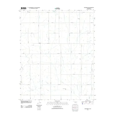
2012 Map of Anadarko NE
USGS Topo · Published 2012About this map
Dutton sits at the intersection of Co Road 1250 and N2750 Rd, serving as a central point in this rural Grady County landscape. The area is defined by a grid of agricultural roads and the branching drainage systems of Ionine Creek and Jack Hollow Creek. To the north, the Ionine Cr Site 101 Reservoir manages local water resources, while the Northeast Verden Oil Field in the south illustrates the region's energy production history. Small landmarks of local heritage are preserved here, including the Friendship Cem and Liberty Cem, which offer significant points of interest for genealogists and local historians studying the families who settled this Oklahoma prairie land. The map reveals a transition between established homesteads and active industrial use, with various forks like W Ionine Cr and E Jack Hollow Cr carving through the countryside.
Find a feature on this map
39 named features on this map. Tap any name to fly to it.
Don’t see what you’re looking for? This feature index may not catch every label — zoom into the map to look around manually.
Map Details
Editions of this 2012 Anadarko NE Map
This is the sole edition of this map. No revisions or reprints were ever made.
Other maps of this area

1893 · Buggy Creek
USGS Topo · 1:62,500

1893 · Minco
USGS Topo · 1:62,500

1904 · Chickasha
USGS Topo · 1:125,000

1945 · Anadarko
USGS Topo · 1:62,500

1954 · Oklahoma City
USGS Topo · 1:250,000

1955 · Clinton
USGS Topo · 1:250,000

1957 · Clinton
USGS Topo · 1:250,000

1957 · Oklahoma City
USGS Topo · 1:250,000

1963 · Oklahoma City
USGS Topo · 1:250,000
1966 · Chickasha
USGS Topo · 1:24,000