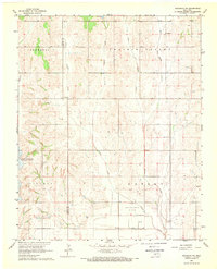
1968 Map of Anadarko NE
USGS Topo · Published 1969About this map
The Caddo and Grady County line divides this agricultural landscape of central Oklahoma during the late 1960s. The small settlement of Dutton and landmarks like Friendship Ch and Liberty Cem anchor the rural community, providing specific coordinates for genealogical research. The terrain is defined by the Jefferson Prairie Valley and cut by numerous waterways including Stinking Cr, Ionine Creek, and Jack Hollow Creek.
Find a feature on this map
16 named features on this map. Tap any name to fly to it.
Don’t see what you’re looking for? This feature index may not catch every label — zoom into the map to look around manually.
Map Details
Editions of this 1968 Anadarko NE Map
This is the sole edition of this map. No revisions or reprints were ever made.
Other maps of this area

1893 · Buggy Creek
USGS Topo · 1:62,500

1893 · Minco
USGS Topo · 1:62,500

1904 · Chickasha
USGS Topo · 1:125,000

1945 · Anadarko
USGS Topo · 1:62,500

1954 · Oklahoma City
USGS Topo · 1:250,000

1955 · Clinton
USGS Topo · 1:250,000

1957 · Clinton
USGS Topo · 1:250,000

1957 · Oklahoma City
USGS Topo · 1:250,000

1963 · Oklahoma City
USGS Topo · 1:250,000
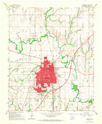
1966 · Chickasha
USGS Topo · 1:24,000