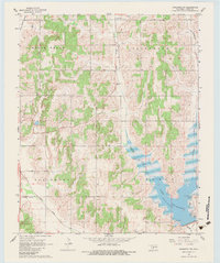
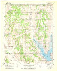
1968 Map of Anadarko NW
USGS Topo · Published 1983About this map
Lake Chickasha dominates the southeastern quadrant of this Caddo County landscape, its irregular shoreline shaped by the inundation of Spring Creek and several smaller tributaries. This late 1960s survey captures the area as a developed recreation and water resource, highlighting specific amenities like the Picnic Area and Trailer Park along the lake's eastern banks. The surrounding terrain is organized into large named sections, including White Bread, Jefferson, Gracemont, and Lincoln, reflecting the township and range grid system of central Oklahoma.
Find a feature on this map
15 named features on this map. Tap any name to fly to it.
Don’t see what you’re looking for? This feature index may not catch every label — zoom into the map to look around manually.
Map Details
Editions of this 1968 Anadarko NW Map
2 editions found
Other maps of this area

1893 · Buggy Creek
USGS Topo · 1:62,500

1945 · Anadarko
USGS Topo · 1:62,500

1951 · Binger
USGS Topo · 1:62,500

1951 · Fort Cobb
USGS Topo · 1:62,500

1955 · Clinton
USGS Topo · 1:250,000

1957 · Clinton
USGS Topo · 1:250,000
1967 · Cogar
USGS Topo · 1:24,000
1968 · Cogar SE
USGS Topo · 1:24,000
1968 · Anadarko NE
USGS Topo · 1:24,000
1968 · Anadarko NW
USGS Topo · 1:24,000