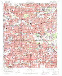
1965 Map of Anaheim
USGS Topo · Published 1972About this map
Disneyland and the surrounding tourism infrastructure anchor this mid-century look at central Orange County during a period of intense suburbanization. The map documents the rapid expansion of Anaheim, Garden Grove, and Buena Park, showing the density of new residential tracts and school construction required for the postwar population boom. Landmarks like Knott's Berry Farm and the Anaheim Stadium illustrate the region's shift toward major entertainment and professional sports.
Find a feature on this map
77 named features on this map. Tap any name to fly to it.
Don’t see what you’re looking for? This feature index may not catch every label — zoom into the map to look around manually.
Map Details
Editions of this 1965 Anaheim Map
3 editions found
Other maps of this area

1896 · Santa Ana
USGS Topo · 1:62,500

1896 · Anaheim
USGS Topo · 1:62,500

1896 · Las Bolsas
USGS Topo · 1:62,500

1896 · Downey
USGS Topo · 1:62,500

1898 · Anaheim
USGS Topo · 1:62,500

1899 · Downey
USGS Topo · 1:62,500

1901 · Southern California Sheet No. 1
USGS Topo · 1:250,000

1901 · Santa Ana
USGS Topo · 1:62,500

1901 · Anaheim
USGS Topo · 1:62,500

1902 · Downey
USGS Topo · 1:62,500