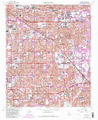
1965 Map of Anaheim
USGS Topo · Published 1981About this map
Anaheim and the surrounding Citrus Belt landscapes are shown in a period of intense post-war urbanization and suburban expansion. The infrastructure of the entertainment age is firmly established, with the grounds of Disneyland and Knott's Berry Farm serving as major regional anchors alongside Anaheim Stadium. The transition from an agricultural past to a residential and industrial hub is evident in the dense street grids of Fullerton, Garden Grove, and Santa Ana that now cover much of the terrain. The sheet provides a clear look at the region's complex transit network, from the heavy rail lines of the Atchison Topeka and Santa Fe and Southern Pacific to the modern corridors of the Santa Ana Freeway. Numerous educational and civic institutions, including Connelly High Sch and the County Hospital, are mapped amidst the expanding residential blocks.
Find a feature on this map
49 named features on this map. Tap any name to fly to it.
Don’t see what you’re looking for? This feature index may not catch every label — zoom into the map to look around manually.
Map Details
Editions of this 1965 Anaheim Map
3 editions found
Other maps of this area

1896 · Santa Ana
USGS Topo · 1:62,500

1896 · Anaheim
USGS Topo · 1:62,500

1896 · Las Bolsas
USGS Topo · 1:62,500

1896 · Downey
USGS Topo · 1:62,500

1898 · Anaheim
USGS Topo · 1:62,500

1899 · Downey
USGS Topo · 1:62,500

1901 · Southern California Sheet No. 1
USGS Topo · 1:250,000

1901 · Santa Ana
USGS Topo · 1:62,500

1901 · Anaheim
USGS Topo · 1:62,500

1902 · Downey
USGS Topo · 1:62,500