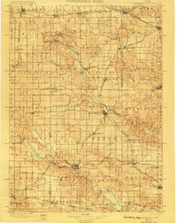
1900 Map of Anamosa
USGS Topo · Published 1900About this map
The Wapsipinicon River and Maquoketa River systems define the drainage and settlement patterns of Jones and Delaware counties in this late nineteenth-century study. The region's development is anchored by the junction of significant rail lines, including the Chicago Milwaukee & St. Paul Ry. and the Illinois Central R.R., which connected agricultural centers like Anamosa, Monticello, and Manchester. Smaller, potentially vanished locales such as Sand Spring, Hazel Green, and Rockville appear along the river forks and railway spurs, providing a look at rural Iowa life before the consolidation of modern transit. The map's intricate contouring reveals the dissected plateau landscape where the South Fork Maquoketa River carves through the central terrain, influencing the placement of early settlements and mills. For genealogists, the identification of precise municipal boundaries and small post villages like Langworthy and Martelle offers a valuable resource for tracing family locations during a period of high railroad activity.
Find a feature on this map
59 named features on this map. Tap any name to fly to it.
Don’t see what you’re looking for? This feature index may not catch every label — zoom into the map to look around manually.
Map Details
Editions of this 1900 Anamosa Map
4 editions found

Other maps of this area

1887 · Cedar Rapids
USGS Topo · 1:62,500

1888 · Marion
USGS Topo · 1:62,500

1889 · Tipton
USGS Topo · 1:62,500

1889 · Marion
USGS Topo · 1:62,500

1890 · Tipton
USGS Topo · 1:62,500

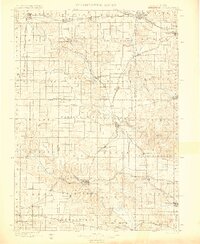
1890 · Anamosa
USGS Topo · 1:62,500

1891 · Monticello
USGS Topo · 1:62,500

1891 · Mechanicsville
USGS Topo · 1:62,500

1891 · Cedar Rapids
USGS Topo · 1:62,500

1891 · Baldwin
USGS Topo · 1:62,500