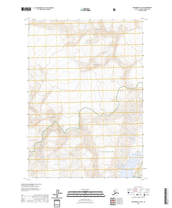
2023 Map of Anchorage A-4 NE
USGS Topo · Published 2023About this map
Chugach National Forest encompasses the high-altitude terrain of this coastal Alaskan landscape, where massive ice fields flow toward the Pacific Ocean. The geography is defined by the convergence of several significant ice bodies, including the Gannett Glacier and the Barry Glacier, which carve through the peaks of the Chugach Range. High points such as Mt Gannett, Globemaster Peak, and Mt Gilbert anchor the survey, illustrating the vertical scale of the region. The map details the complex glacial margins of the Cascade Glacier and the Serpentine Glacier as they interact with the sea and the surrounding protected forest lands, providing a clear record of the glacial extent and topographic relief in this wilderness area as it appeared in 2023.
Find a feature on this map
13 named features on this map. Tap any name to fly to it.
Don’t see what you’re looking for? This feature index may not catch every label — zoom into the map to look around manually.
Map Details
Editions of this 2023 Anchorage A-4 NE Map
This is the sole edition of this map. No revisions or reprints were ever made.
Other maps of this area

1951 · Anchorage
USGS Topo · 1:250,000

1960 · Anchorage A-4
USGS Topo · 1:63,360

1960 · Anchorage A-3
USGS Topo · 1:63,360

1960 · Anchorage B-4
USGS Topo · 1:63,360

1960 · Anchorage B-3
USGS Topo · 1:63,360

1962 · Anchorage
USGS Topo · 1:250,000

1979 · Anchorage
USGS Topo · 1:250,000

1994 · Anchorage B-4
USGS Topo · 1:63,360
2013 · Anchorage B-4 SW
USGS Topo · 1:25,000
2013 · Anchorage A-3 NW
USGS Topo · 1:25,000