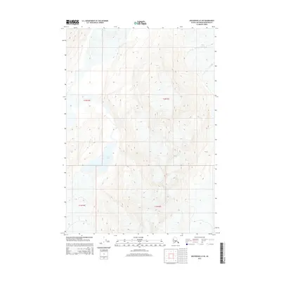
2015 Map of Anchorage A-5 NE
USGS Topo · Published 2015About this map
Lake George sits at the heart of this high-elevation landscape in the Anchorage municipality, a region defined by dramatic vertical relief and glacial movement. The presence of Colony Glacier in the northeast corner illustrates the active ice-and-water dynamics that have shaped the Chugach Mountains, as shown in this 2015 update from the U.S. Geological Survey. Surveyed sections for Townships 13 and 12 North are demarcated across the terrain, reflecting the foundational Public Land Survey System framework managed by the Bureau of Land Management. This map provides a technical view of the hydrography and topography of the Alaskan interior where natural features dictate the boundaries of human organization.
Find a feature on this map
6 named features on this map. Tap any name to fly to it.
Don’t see what you’re looking for? This feature index may not catch every label — zoom into the map to look around manually.
Map Details
Editions of this 2015 Anchorage A-5 NE Map
This is the sole edition of this map. No revisions or reprints were ever made.
Other maps of this area

1951 · Anchorage
USGS Topo · 1:250,000

1960 · Anchorage A-5
USGS Topo · 1:63,360

1960 · Anchorage A-4
USGS Topo · 1:63,360

1960 · Anchorage B-5
USGS Topo · 1:63,360

1960 · Anchorage B-4
USGS Topo · 1:63,360

1962 · Anchorage
USGS Topo · 1:250,000

1979 · Anchorage
USGS Topo · 1:250,000

1994 · Anchorage B-4
USGS Topo · 1:63,360
1994 · Anchorage B-5
USGS Topo · 1:63,360
2013 · Anchorage B-4 SW
USGS Topo · 1:25,000