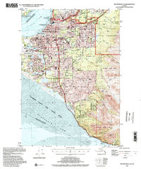
1994 Map of Anchorage A-8
USGS Topo · Published 2002About this map
Anchorage and its expanding urban footprint dominate this mid-1990s landscape, illustrating the dense residential and commercial growth between the Knik Arm and the towering peaks of the Chugach. The city's critical role as an aviation and educational hub is clear, with major installations like the Anchorage International Airport, Merrill Field Airport, and the neighboring campuses of Univ of Alaska Anchorage and Alaska Pacific Univ. Further east, the Fort Richardson Military Reservation and Elmendorf Air Force Base occupy vast tracts, while the Alaska Railroad skirts the coastline toward the southern settlement of Potter. This survey provides a look at the transition from the structured grid of neighborhoods like Mountain View and Spenard to the protected wilderness of Chugach State Park and the tidal flats of the Anchorage Coastal State Wildlife Refuge.
Find a feature on this map
58 named features on this map. Tap any name to fly to it.
Don’t see what you’re looking for? This feature index may not catch every label — zoom into the map to look around manually.
Map Details
Editions of this 1994 Anchorage A-8 Map
This is the sole edition of this map. No revisions or reprints were ever made.
Other maps of this area

1944 · Kenai
USGS Topo · 1:250,000

1949 · Tyonek
USGS Topo · 1:250,000

1950 · Kenai
USGS Topo · 1:250,000

1951 · Seward
USGS Topo · 1:250,000

1951 · Anchorage
USGS Topo · 1:250,000

1951 · Tyonek
USGS Topo · 1:250,000

1951 · Kenai D-1
USGS Topo · 1:63,360

1951 · Seward D-8
USGS Topo · 1:63,360

1951 · Seward D-7
USGS Topo · 1:63,360

1951 · Tyonek A-1
USGS Topo · 1:63,360