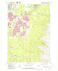
1979 Map of Anchorage A-8 NE
USGS Topo · Published 1980About this map
The growing urban landscape of Anchorage meets the wilderness at the base of the Chugach Mountains in this late 1970s topographical record. The map reveals a city in transition, where established neighborhoods like Hillside and Whitney expand alongside massive military installations at Elmendorf Air Force Base and the Fort Richardson Military Reservation. The proliferation of educational institutions, such as Alaska Methodist Univ and Service-Hanshew High Sch, underscores the rapid mid-century development of the region.
Find a feature on this map
43 named features on this map. Tap any name to fly to it.
Don’t see what you’re looking for? This feature index may not catch every label — zoom into the map to look around manually.
Map Details
Editions of this 1979 Anchorage A-8 NE Map
3 editions found
Other maps of this area

1951 · Anchorage
USGS Topo · 1:250,000

1952 · Anchorage A-8
USGS Topo · 1:63,360

1952 · Anchorage B-8
USGS Topo · 1:63,360

1953 · Anchorage A-8
USGS Topo · 1:63,360

1953 · Anchorage B-8
USGS Topo · 1:63,360

1960 · Anchorage B-7
USGS Topo · 1:63,360

1960 · Anchorage A-7
USGS Topo · 1:63,360

1962 · Anchorage
USGS Topo · 1:250,000

1965 · Anchorage B-8
USGS Topo · 1:63,360

1979 · Anchorage B-7 SW
USGS Topo · 1:25,000