
1960 Map of Anchorage B-1
USGS Topo · Published 1965About this map
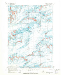
Harvard Glacier and Columbia Glacier dominate this high-altitude Alaskan landscape, where massive ice fields and sharp peaks define the topography. Surveyed in the mid-1950s, the map documents the convergence of several major glacial systems, including the Yale Glacier and the Second Branch Columbia Glacier. The ice flows are punctuated by formidable summits named for historical figures and mythological entities, such as Mount Einstein, Mount Valhalla, and Mount Edison.
Find a feature on this map
21 named features on this map. Tap any name to fly to it.
Don’t see what you’re looking for? This feature index may not catch every label — zoom into the map to look around manually.
Map Details
Editions of this 1960 Anchorage B-1 Map
2 editions found
Other maps of this area

1951 · Anchorage
USGS Topo · 1:250,000

1952 · Valdez
USGS Topo · 1:250,000

1960 · Valdez A-8
USGS Topo · 1:63,360

1960 · Anchorage A-2
USGS Topo · 1:63,360

1960 · Anchorage A-1
USGS Topo · 1:63,360

1960 · Anchorage C-2
USGS Topo · 1:63,360

1960 · Anchorage B-2
USGS Topo · 1:63,360

1960 · Valdez B-8
USGS Topo · 1:63,360

1960 · Valdez C-8
USGS Topo · 1:63,360

1960 · Anchorage C-1
USGS Topo · 1:63,360