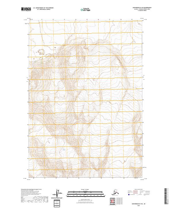
2023 Map of Anchorage B-4 SE
USGS Topo · Published 2023About this map
Gannett Glacier dominates the southern reaches of this high-altitude landscape in the Chugach Census Area, reflecting the glacial processes that continue to shape the Alaskan wilderness. This 2023 survey provides a contemporary perspective on the icy expanses and complex topography of south-central Alaska. The terrain is marked by extreme elevation changes, documented through dense contour intervals that define the ridges and valleys between townships such as t15n r7e and t14n r7e. While the map lacks the industrial or residential development common in lower latitudes, the presence of these precise township and range boundaries serves as the primary grid for navigation and land management in this remote subarctic environment.
Find a feature on this map
7 named features on this map. Tap any name to fly to it.
Don’t see what you’re looking for? This feature index may not catch every label — zoom into the map to look around manually.
Map Details
Editions of this 2023 Anchorage B-4 SE Map
This is the sole edition of this map. No revisions or reprints were ever made.
Other maps of this area

1951 · Anchorage
USGS Topo · 1:250,000

1960 · Anchorage A-4
USGS Topo · 1:63,360

1960 · Anchorage A-3
USGS Topo · 1:63,360

1960 · Anchorage B-4
USGS Topo · 1:63,360

1960 · Anchorage B-3
USGS Topo · 1:63,360

1962 · Anchorage
USGS Topo · 1:250,000

1979 · Anchorage
USGS Topo · 1:250,000

1994 · Anchorage B-4
USGS Topo · 1:63,360
2013 · Anchorage B-4 SW
USGS Topo · 1:25,000
2013 · Anchorage A-3 NW
USGS Topo · 1:25,000