
1960 Map of Anchorage C-3
USGS Topo · Published 1965About this map
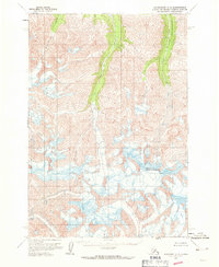
Glacier Creek and Gravel Creek carve through the high mountain topography of this 1960s survey, illustrating a landscape defined by glacial activity and shifting ice. The presence of extensive Crevasses across the southern portion of the sheet indicates a dynamic alpine environment where frozen terrain dictates the movement of water and ice. To the west, Monument Creek flows through deep valleys, part of a watershed that remained largely untouched by permanent settlement or road infrastructure during this era. Produced by the U.S. Geological Survey from 1957 aerial photography and 1960 field annotations, the map documents a period before modern development, where gray land lines represent unsurveyed locations predetermined by the Bureau of Land Management.
Find a feature on this map
4 named features on this map. Tap any name to fly to it.
Don’t see what you’re looking for? This feature index may not catch every label — zoom into the map to look around manually.
Map Details
Editions of this 1960 Anchorage C-3 Map
2 editions found
Other maps of this area

1948 · Anchorage D-3
USGS Topo · 1:63,360

1948 · Anchorage D-2
USGS Topo · 1:63,360

1948 · Anchorage D-4
USGS Topo · 1:63,360

1951 · Anchorage
USGS Topo · 1:250,000

1952 · Anchorage D-2
USGS Topo · 1:63,360

1952 · Anchorage D-4
USGS Topo · 1:63,360

1952 · Anchorage D-3
USGS Topo · 1:63,360

1960 · Anchorage C-2
USGS Topo · 1:63,360

1960 · Anchorage B-4
USGS Topo · 1:63,360

1960 · Anchorage B-3
USGS Topo · 1:63,360