
1952 Map of Anchorage C-8
USGS Topo · Published 1952About this map
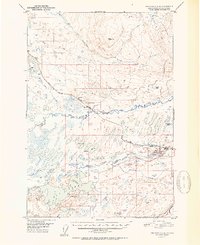
The settlement at Houston serves as the industrial and transportation hub for this portion of the Matanuska-Susitna region during the early 1950s. Positioned along the Alaska Railroad, the area's economy is clearly tied to resource extraction, as evidenced by the Coal Mine, Houston Strip Mine, and a nearby Gravel Pit. The map captures a landscape defined by an intricate network of waterways and glacial lakes, including the expansive Big Lake, Nancy Lake, and the winding course of the Little Susitna River.
Find a feature on this map
26 named features on this map. Tap any name to fly to it.
Don’t see what you’re looking for? This feature index may not catch every label — zoom into the map to look around manually.
Map Details
Editions of this 1952 Anchorage C-8 Map
2 editions found
Other maps of this area

1949 · Tyonek
USGS Topo · 1:250,000

1949 · Anchorage D-7
USGS Topo · 1:63,360

1949 · Anchorage D-8
USGS Topo · 1:63,360

1950 · Anchorage C-8
USGS Topo · 1:63,360

1950 · Anchorage C-7
USGS Topo · 1:63,360

1951 · Anchorage
USGS Topo · 1:250,000

1951 · Tyonek
USGS Topo · 1:250,000

1951 · Anchorage C-7
USGS Topo · 1:63,360

1951 · Anchorage D-8
USGS Topo · 1:63,360

1951 · Anchorage D-7
USGS Topo · 1:63,360