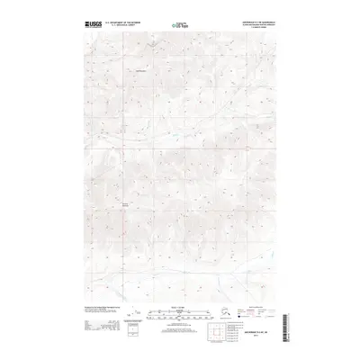
2013 Map of Anchorage D-2 NE
USGS Topo · Published 2013About this map
Horn Mountain dominates the northern reaches of this Alaskan landscape, part of a high-altitude drainage network within the Matanuska-Susitna Borough. The terrain is defined by its complex hydrologic system, where Alfred Cr and Wood Cr flow through the high country. To the south, Syncline Mountain provides a prominent geological anchor near the headwaters of Papoose Cr and Inoceramus Cr. The presence of Squaw Lake and the convergence of several small streams like Flame Cr and Gunsight Cr suggest a landscape shaped by seasonal melt and glacial history. This 2013 survey illustrates the remote character of the Talkeetna Mountains, showing a territory governed primarily by its topography and watercourses rather than human infrastructure or settlement.
Find a feature on this map
12 named features on this map. Tap any name to fly to it.
Don’t see what you’re looking for? This feature index may not catch every label — zoom into the map to look around manually.
Map Details
Editions of this 2013 Anchorage D-2 NE Map
This is the sole edition of this map. No revisions or reprints were ever made.
Other maps of this area

1948 · Anchorage D-2
USGS Topo · 1:63,360

1948 · Anchorage D-1
USGS Topo · 1:63,360

1949 · Talkeetna Mountains A-1
USGS Topo · 1:63,360

1950 · Talkeetna Mountains
USGS Topo · 1:250,000

1951 · Anchorage
USGS Topo · 1:250,000

1951 · Anchorage D-1
USGS Topo · 1:63,360

1951 · Talkeetna Mountains A-2
USGS Topo · 1:63,360

1952 · Anchorage D-2
USGS Topo · 1:63,360
1952 · Talkeetna Mountains A-1
USGS Topo · 1:63,360
1952 · Talkeetna Mountains A-2
USGS Topo · 1:63,360