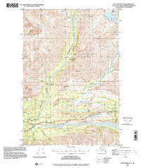
1994 Map of Anchorage D-4
USGS Topo · Published 2001About this map
The Matanuska Valley serves as the central corridor of this 1994 survey, where the Matanuska River flows alongside the Glenn Highway. This landscape is defined by the sharp transition from the valley floor to the high peaks of the Talkeetna Mountains and the prominent Anthracite Ridge. Historically, this area was a vital route through the Alaskan interior, evidenced by the presence of the Knik Nelchina Trail and several remote outposts including Ninemile Cabin and Fourteenmile Cabin.
Find a feature on this map
43 named features on this map. Tap any name to fly to it.
Don’t see what you’re looking for? This feature index may not catch every label — zoom into the map to look around manually.
Map Details
Editions of this 1994 Anchorage D-4 Map
This is the sole edition of this map. No revisions or reprints were ever made.
Other maps of this area

1948 · Anchorage D-3
USGS Topo · 1:63,360

1948 · Anchorage D-4
USGS Topo · 1:63,360

1949 · Anchorage D-5
USGS Topo · 1:63,360

1949 · Talkeetna Mountains A-4
USGS Topo · 1:63,360

1950 · Talkeetna Mountains
USGS Topo · 1:250,000

1951 · Anchorage
USGS Topo · 1:250,000

1951 · Anchorage C-5
USGS Topo · 1:63,360

1951 · Talkeetna Mountains A-3
USGS Topo · 1:63,360

1952 · Anchorage D-5
USGS Topo · 1:63,360

1952 · Anchorage D-4
USGS Topo · 1:63,360