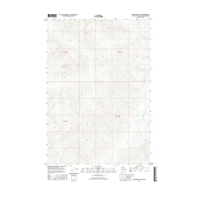
2016 Map of Anchorage D-4 NW
USGS Topo · Published 2016About this map
The Chickaloon River valley dominates the lower southeast portion of this high-elevation Alaskan terrain, where the river winds through steep elevation gradients. This 2016 survey of the Matanuska-Susitna Borough reveals a landscape defined by significant drainage systems, including the waters of Moss Creek and Doone Cr in the northern and eastern reaches. The map focuses on the physical geography and hydrography of the Talkeetna Mountains area, providing detailed contour data for the drainages that feed into the larger river system. While the region remains largely uninhabited by permanent settlements, the precise mapping of Moss Cr and other small tributaries illustrates the complex network of mountain waterways within the Matanuska-Susitna wilderness.
Find a feature on this map
8 named features on this map. Tap any name to fly to it.
Don’t see what you’re looking for? This feature index may not catch every label — zoom into the map to look around manually.
Map Details
Editions of this 2016 Anchorage D-4 NW Map
This is the sole edition of this map. No revisions or reprints were ever made.
Other maps of this area

1948 · Anchorage D-4
USGS Topo · 1:63,360

1949 · Anchorage D-5
USGS Topo · 1:63,360

1949 · Talkeetna Mountains A-4
USGS Topo · 1:63,360

1950 · Talkeetna Mountains
USGS Topo · 1:250,000

1951 · Anchorage
USGS Topo · 1:250,000

1951 · Talkeetna Mountains A-3
USGS Topo · 1:63,360

1952 · Anchorage D-5
USGS Topo · 1:63,360

1952 · Anchorage D-4
USGS Topo · 1:63,360
1952 · Talkeetna Mountains A-3
USGS Topo · 1:63,360
1954 · Talkeetna Mountains A-4
USGS Topo · 1:63,360