
1954 Map of Talkeetna Mountains A-4
USGS Topo · Published 1954About this map
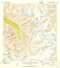
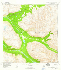
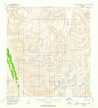
The Talkeetna Mountains define this high-altitude landscape, documented through aerial photography taken in 1949 and 1954. This particular quadrangle focuses on a transition point of significant glacial movement and drainage, where the massive ice fields of Talkeetna Glacier and Chickaloon Glacier dominate the eastern and southern high ground. These frozen reservoirs feed a network of cold-water systems, most notably Sheep Creek, which cuts through the central terrain. Unlike lower elevation surveys, the presence of "unchecked elevations" in both brown and blue contours indicates the extreme difficulty of early ground-truthing in this portion of the Alaska-Third Judicial Division. The map reveals the intricate natural drainage patterns into Iron Cr, providing a foundational study of the area's hydrology before later development or climate-driven changes altered these ice margins.
Find a feature on this map
5 named features on this map. Tap any name to fly to it.
Don’t see what you’re looking for? This feature index may not catch every label — zoom into the map to look around manually.
Map Details
Editions of this 1954 Talkeetna Mountains A-4 Map
2 editions found
Other maps of this area
1948 · Anchorage D-4
USGS Topo · 1:63,360
1949 · Anchorage D-5
USGS Topo · 1:63,360
1949 · Talkeetna Mountains A-4
USGS Topo · 1:63,360

1950 · Talkeetna Mountains
USGS Topo · 1:250,000
1950 · Talkeetna Mountains B-5
USGS Topo · 1:63,360
1950 · Talkeetna Mountains B-4
USGS Topo · 1:63,360
1950 · Anchorage D-6
USGS Topo · 1:63,360
1950 · Talkeetna Mountains A-5
USGS Topo · 1:63,360

1951 · Anchorage
USGS Topo · 1:250,000
1951 · Talkeetna Mountains B-3
USGS Topo · 1:63,360